The Anatomy of Earth Observation - Data Acquisition

Hello Readers,
We are back after a 3 year break, it’s hard to believe how quickly the time has flown! As we step into this new chapter in 2025, the Startups and ***** series is evolving to bring you deeper insights and richer content. Thank you for sticking with me, let’s dive into this journey together!
Earth Observation:
Ever wondered how we keep tabs on our planet from miles above? That’s the magic of Earth observation! Using satellites, drones, and sensors, we gather incredible data about the land, oceans, and atmosphere. It helps us do everything from predicting weather and managing natural disasters to boosting crop yields and tracking urban growth. Think of it as a real-time health check for Earth, giving us the insights we need to tackle challenges like climate change and resource management. Pretty cool, right? It’s like having a bird’s-eye view of our planet’s story, helping us make smarter, more sustainable choices. Lets dive in:
Earth’s surface can be observed from different platforms, each presenting its own advantages and limitations. Aerial platforms, for instance, generally provide the best resolutions and are very adjustable to the users’ needs, but the high cost of chartering a plane and paying the related manpower (pilots and technicians) restricts its use. Drones are a fast-growing technology that tackles this cost problem, but regulations and their low carrying capacity currently limits their range of activity. On the other hand, satellites allow for reliable, true global coverage even above the most remote locations enabling regular repeat observations.
There are 3 major segments in EO:
Data Acquisition: Capturing raw data via satellites, drones, and ground sensors.
Data Processing and Analytics: Converting raw data into actionable insights.
Applications: Serving diverse industries with specific insights such as agriculture, defense, disaster management, energy, and urban planning.
In this blog we will be focusing on the Data Acquisition part, we will dove into various sensors, their application and shed some light on the market and Indian companies working in this space.

Techniques of Earth Observation:

Passive sensors rely on natural energy like sunlight or thermal emissions, making them cost-efficient and ideal for broad applications such as agriculture and environmental monitoring. However, they are limited by weather and lighting, restricting data consistency.
Active sensors generate their own energy, enabling reliable data collection anytime, regardless of conditions, making them essential for high-value use cases like infrastructure monitoring, disaster management, and defense. Active sensors often require higher upfront investment but unlock premium business opportunities due to their versatility and reliability, driving significant ROI in critical industries.
The key difference lies in energy dependency: passive sensors depend on external energy, while active sensors are self-reliant and more versatile.
Before we dive into the details, here below is the electromagnetic spectrum for your reference:

Passive Sensors - Source of energy: Sun & Earth

Panchromatic:
Panchromatic imaging captures high-resolution images by measuring the intensity of light across a broad range of wavelengths, typically in the visible spectrum. Collecting light from a wide range of wavelengths allows for more energy being collected and hence high resolution images (up to 30 cm in resolution for the best commercially available satellite instruments).
Panchromatic sensors provide greater spatial resolution, making them ideal for detailed mapping, urban planning, and infrastructure monitoring. The data is often used alongside multispectral images to enhance detail in applications like precision agriculture, disaster assessment, and defense. Its ability to deliver high-detail imagery makes it a valuable asset for industries requiring fine-grained geospatial intelligence.

Multi-spectral:
Multispectral imaging in Earth observation captures data across multiple specific wavelength bands, including visible, near-infrared, and sometimes shortwave infrared. This enables the detection of unique spectral signatures from surfaces, making it ideal for analyzing physical and chemical properties of objects. By combining data from different bands, multispectral imaging provides insights that are not visible to the naked eye, such as vegetation health, soil composition, and water quality.
Multispectral imaging supports crop health monitoring, forest management, water quality analysis, urban planning, disaster response, and mineral exploration. By capturing data across spectral bands, it provides critical insights for sustainable development and resource optimization.

Pan-sharpened:
Pan-sharpening in Earth observation combines high-resolution panchromatic images with lower-resolution multispectral images to create a single, high-resolution color image. This enhances the spatial detail of the multispectral data while retaining its spectral information, making it ideal for applications requiring both clarity and color accuracy.
Pan-sharpened imagery enhances spatial and spectral data, enabling detailed applications like urban mapping, crop monitoring, disaster assessment, defense reconnaissance, and environmental tracking. Its high-resolution clarity and color accuracy make it invaluable for precise analysis and decision-making across industries.

Hyper-spectral:
Hyperspectral imaging in Earth observation captures data across hundreds of narrow, contiguous spectral bands, providing highly detailed spectral information for each pixel. This enables the identification of unique material signatures and subtle variations in surface composition, making it ideal for advanced analysis and monitoring.

Hyperspectral imaging enables advanced analysis across industries by identifying unique material signatures. It supports crop health monitoring, pollution tracking, mineral exploration, disaster assessment, and defense reconnaissance. Its ability to capture detailed spectral data provides unmatched precision for environmental and resource management.

Microwave Radiometry:
Microwave radiometry in Earth observation measures natural microwave emissions from Earth’s surface and atmosphere, providing data on physical properties like temperature, moisture, and salinity. Unlike optical methods, it penetrates clouds and works day or night, making it highly reliable for all-weather observations.
The main objective of the Microwave Radiometer (MWR) is the measurement of the integrated atmospheric water vapour column and cloud liquid water content. MWR measurement data are useful for the determination of surface emissivity and soil moisture over land, for surface energy budget investigations to support atmospheric studies, and for ice characterization.
Active Sensors - Source of energy: Satellite

Synthetic Aperture Radar:
The most common active sensor used for Earth Observation is the Synthetic Aperture Radar (SAR). This instrument transmits electromagnetic pulses towards the Earth’s surface where they are reflected or scattered by the surface features. The instrument’s antenna can detect and record the return pulses. The intensity of the return pulse and the time it takes to arrive back at the antenna are used to generate SAR imagery.
The main advantage of radar imaging is that it is insensitive to the day/night cycle and most of the time to the meteorological conditions (shorter wavelength signals such as X-band can be degraded by heavy intense rain cells). Applications include ship detection, oil spill detection, sea ice monitoring, forest monitoring, soil moisture, critical infrastructure, etc.

By using a technique known as SAR interferometry, highly accurate measurements of geophysical parameters such as surface topography, ground deformation and subsidence and glacier movements can be made. In SAR interferometry, the phase of two or more complex radar images are compared that have been acquired from slightly different positions or at different times. Since the phase of each SAR image pixel contains range information that is accurate to a small fraction of the radar wavelength, it is possible to detect and measure path length differences with centimetric or even millimetric precision.
Lidar:
LiDAR (Light Detection and Ranging) in Earth observation uses laser pulses to measure distances and create highly detailed 3D maps of the Earth's surface. It is especially effective for capturing elevation data and fine surface details, even in densely vegetated areas.
Lidar uses the same principle as SAR but works in the IR, visible or UV wavelengths. Lidars are used for precise measurement of topographic features, monitoring growth or decline of glaciers, profiling clouds, measuring winds, studying aerosols and quantifying various atmospheric components.

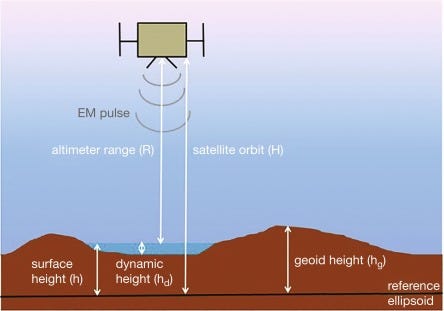
Radar Altimetry:
Radar altimetry measures the distance between a satellite and the Earth's surface by sending radar pulses and analyzing the return signal. This technique is essential for monitoring surface elevations over land, sea, and ice with high accuracy.They provide precise measurements of a satellite's height above the ocean by measuring the time interval between the transmission and reception of very short electromagnetic pulses.
GNSS-R:
GNSS Reflectometry (GNSS-R) leverages signals from navigation satellites (e.g., GPS) reflected off the Earth's surface to extract environmental information. This passive, cost-efficient technique is increasingly valuable for monitoring large-scale surface characteristics.
GNSS Reflectometry (GNSS-R) enables cost-effective Earth observation by analyzing reflected satellite signals to monitor soil moisture, sea surface height, wave roughness, and inland water bodies. It supports flood detection, cryosphere studies, and climate research, offering scalable solutions for environmental and resource management.

Radar Scatterometry:
Radar scatterometry in Earth observation uses radar waves to measure the reflection or scattering of signals from the Earth's surface. By analyzing the backscatter, scatterometers provide valuable information about surface roughness, wind speed, and ocean characteristics.
Radar scatterometry is used to measure sea surface roughness and wind speed, supporting oceanography and climate monitoring. It helps in soil moisture assessment for agriculture, observes coastal changes, and aids in disaster response by detecting environmental hazards like oil spills. Its ability to operate in all weather conditions makes it a valuable tool for consistent, global environmental monitoring.

Note:
Penetration Power: Longer wavelengths (such as in the microwave or radio ranges) can penetrate through clouds, vegetation, and soil, making techniques like SAR, radar altimetry, and GNSS-R effective in areas where optical systems (like panchromatic or multi-spectral) would struggle due to weather or surface conditions.
Resolution: Higher-frequency bands (like X-band in SAR or Lidar’s near-infrared) typically provide finer resolution and sharper details but may be more sensitive to atmospheric conditions. Lower-frequency bands (like L-band in SAR or microwave radiometry) offer less resolution but better penetration, which is useful for large-scale or deeper observations.
Spectral Sensitivity: Broad spectrum techniques like multi-spectral and hyperspectral imaging can identify a wide range of materials and properties based on their unique spectral signatures, making them highly efficient for monitoring environmental features like vegetation health or pollution.
Atmospheric Interference: Higher-frequency waves, especially in the visible and near-infrared ranges, are often scattered or absorbed by atmospheric particles, reducing their efficiency in certain conditions. Microwave-based techniques (e.g., radar, GNSS-R) are less affected by weather, making them more reliable for all-weather operations.
Industry Use Cases
Now that we have covered the technology aspect of Earth Observation lets dive in to understand why industries requires EO and what areas does it help:
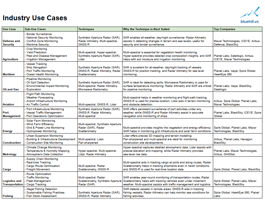
These are some of the existing and emerging use cases, I expect many more industries to adopt EO as the data gets cheaper.
If you want to visualize how the data is used, check out this video series by Hawkeye: https://www.he360.com/resources-archive/hawkeye-101-series/
Indian Earth Observation Satellites - ISRO
Now that we got a sense of what’s in store for us, let us look in detail what kind of EO satellites ISRO is operating.

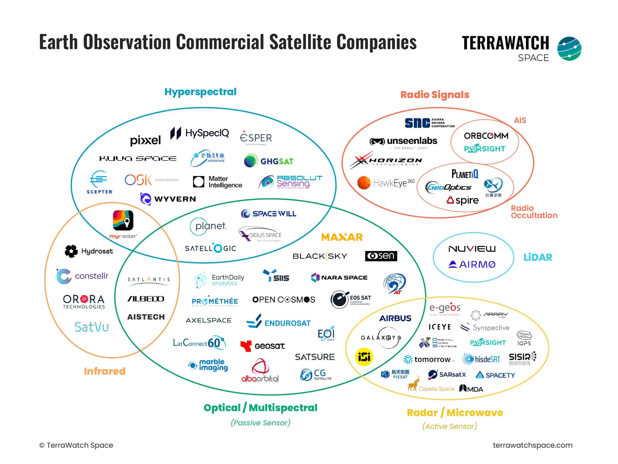
Global Companies
EO is a global market from the get go and there are some pioneering startups who have taken the mantle from govt agencies to make EO data more accessible, here is a snapshot of a few of them:

Indian Startups
EO industry in India is still pretty nascent with a few startups making waves, as the industry matures I believe they will be in pole position to define the way we observe earth.

Some of these startups have already tested or deployed their payloads in space
Pixxel
Shakuntala, Pixxel’s first hyperspectral satellite was launched in April 2022
Pixxel recently unveiled its fireflies (The World’s Highest Resolution Hyperspectral Satellite) constellation: https://www.pixxel.space/blogs/pixxel-unveils-the-fireflies-the-worlds-highest-resolution-hyperspectral-satellite-constellation-set-to-transform-earth-observation

Galaxeye and Piersight
Galaxeye and Piersight’s SAR payloads were launched recently on the PSLV C-60’s PS4-Orbital Experiment Module (POEM-4).
Details: https://www.isro.gov.in/POEM_4_Payloads_spadex.html
The Earth observation industry presents a growing opportunity due to the increasing demand for precise, real-time data across multiple sectors. Advances in satellite technology, including the development of smaller, more cost-effective satellites and sophisticated sensors, have revolutionized how we monitor the planet. This has significantly lowered the entry barriers for new companies, creating a dynamic and competitive market ripe for innovation. The data collected from Earth observation satellites is invaluable for applications in agriculture, environmental monitoring, urban planning, and disaster management, among others.
Constellation-based Earth observation is the talk of the town. This involves deploying multiple small satellites into orbit to work together as a constellation, providing comprehensive and high-resolution data coverage of the Earth's surface. Unlike traditional single-satellite systems, these constellations offer frequent revisit times and enhanced imaging capabilities, enabling near-real-time monitoring of environmental changes, urban development, and various other critical activities. The scalability and reduced costs associated with launching and maintaining smaller satellites have lowered the barriers to entry. Additionally, advancements in machine learning and data analytics further enhance the value of the vast amounts of data collected, creating opportunities for innovative applications across industries.
Thanks for Reading!
If you are a founder, Investor or an ecosystem enabler in EO, would love to chat, drop me a note at sanket.panda@bluehill.vc / sanket7panda@gmail.com
As we part ways, here below is a EO landscape by TerraWatch, try and map where your favorite startups fit in: